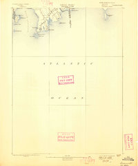
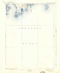
1893 Map of Sakonnet
USGS Topo · Published 1898About this map
The rocky coastline of Little Compton and Middletown defines this late nineteenth-century coastal survey. Dominating the western edge is the Sakonnet River, while the southern tip of the peninsula is anchored by Sakonnet Point and the nearby Breakwater. The map highlights a series of distinctive coastal landmarks, from the exposed Island Rocks and Cormorant Rock to the prominent Sachuest Point. Inland, a cluster of small water bodies like Round Pond, Long Pond, and Tunipus Pond sit just behind the shore, illustrating the fragile barrier-beach geography typical of this era. The Rhode Island Massachusetts Boundary Line is clearly marked at Quicksand Point, showing the historical border configuration before modern development altered the shoreline interface. This survey, conducted under director J.W. Powell, provides a precise record of the natural shoreline before the turn of the century.
Find a feature on this map
28 named features on this map. Tap any name to fly to it.
Don’t see what you’re looking for? This feature index may not catch every label — zoom into the map to look around manually.
Map Details
Editions of this 1893 Sakonnet Map
6 editions found
Other maps of this area

1885 · New Bedford
USGS Topo · 1:62,500

1885 · Sakonnet
USGS Topo · 1:62,500

1888 · New Bedford
USGS Topo · 1:62,500

1888 · Fall River
USGS Topo · 1:62,500

1888 · Sakonnet
USGS Topo · 1:62,500

1889 · Newport
USGS Topo · 1:62,500

1890 · Narragansett Bay
USGS Topo · 1:62,500

1892 · Narragansett Bay
USGS Topo · 1:62,500

1893 · Sakonnet
USGS Topo · 1:62,500

1893 · Fall River
USGS Topo · 1:62,500