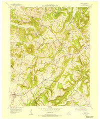
1954 Map of Salem
USGS Topo · Published 1955About this map
Active mining operations define the economy of the Crittenden Co Livingston Co borderlands during the mid-1950s. The landscape is dotted with specialized extractions, including the Keystone Mine and Fluorite Flotation Mill, Glendale Mines, and Eagle Babb Mine. These industrial sites are interspersed with the traditional rural infrastructure of the era, such as Liberty Grove Ch and the Siloam Sch.
Find a feature on this map
81 named features on this map. Tap any name to fly to it.
Don’t see what you’re looking for? This feature index may not catch every label — zoom into the map to look around manually.
Map Details
Editions of this 1954 Salem Map
2 editions found
Other maps of this area

1916 · Fords Ferry
USGS Topo · 1:62,500

1916 · Golconda
USGS Topo · 1:62,500

1920 · Goloonda
USGS Topo · 1:48,000

1921 · Fords Ferry
USGS Topo · 1:48,000

1921 · Golconda
USGS Topo · 1:62,500

1925 · Cave In Rock
USGS Topo · 1:62,500

1928 · Eddyville
USGS Topo · 1:48,000

1929 · Smithland
USGS Topo · 1:62,500

1931 · Eddyville
USGS Topo · 1:62,500

1936 · Eddyville
USGS Topo · 1:48,000