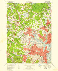
1956 Map of Salem
USGS Topo · Published 1959About this map
Salem and the surrounding North Shore towns are documented here in a period of significant mid-century expansion, where the historical maritime identity meets the modernizing highway age. The map illustrates the complex waterway network of the Danvers River and its tributaries, including the Waters River and Porter River, defining the geography of Danversport and Beverly. On the western hills, the extensive grounds of the Danvers State Hospital and St Johns Preparatory Sch dominate the landscape near Hathorne. In Salem, the layout of the old city is preserved alongside notable landmarks such as the House of Seven Gables and the State Teachers College. The mapping of numerous local schools and cemeteries, like the sprawling Harmony Grove Cemetery and Puritan Lawn Cem, offers a detailed record of the community's social and memorial landscape before later twentieth-century development further altered these Essex County towns.
Find a feature on this map
154 named features on this map. Tap any name to fly to it.
Don’t see what you’re looking for? This feature index may not catch every label — zoom into the map to look around manually.
Map Details
Editions of this 1956 Salem Map
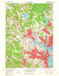
2 editions found
Other maps of this area

1886 · Lawrence
USGS Topo · 1:62,500

1888 · Lawrence
USGS Topo · 1:62,500

1888 · Salem
USGS Topo · 1:62,500

1892 · Boston Bay
USGS Topo · 1:62,500

1893 · Salem
USGS Topo · 1:62,500

1893 · Boston
USGS Topo · 1:62,500

1893 · Lawrence
USGS Topo · 1:62,500

1903 · Boston
USGS Topo · 1:62,500

1903 · Boston Bay
USGS Topo · 1:62,500

1917 · Salem
USGS Topo · 1:62,500