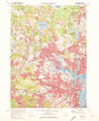
1970 Map of Salem
USGS Topo · Published 1972About this map
Salem and Beverly dominate the North Shore coastline in this 1970 snapshot, showing a dense network of suburban expansion and industrial infrastructure. The landscape is defined by its complex tidal waters, including Salem Harbor, Collins Cove, and the winding Danvers River, while the massive campus of the Danvers State Hospital sits prominently atop the high ground near Hathorne. Inland, the area transitions from the busy maritime and commercial centers of Peabody to the larger open spaces of Topsfield and Wenham, where the Putnamville Reservoir and Wenham Lake provide a sharp contrast to the surrounding residential development. The map meticulously documents the transition of transportation, from the historic Boston and Maine rail corridors to the modern expressway system marked by numerous interchanges such as Interchange 25 and Interchange 26. Notable landmarks for local historians include the Salem Terminal Wharf, Salem State College, and historic sites like Gallows Hill.
Find a feature on this map
151 named features on this map. Tap any name to fly to it.
Don’t see what you’re looking for? This feature index may not catch every label — zoom into the map to look around manually.
Map Details
Editions of this 1970 Salem Map
2 editions found
Other maps of this area

1886 · Lawrence
USGS Topo · 1:62,500

1888 · Lawrence
USGS Topo · 1:62,500

1888 · Salem
USGS Topo · 1:62,500

1892 · Boston Bay
USGS Topo · 1:62,500

1893 · Salem
USGS Topo · 1:62,500

1893 · Boston
USGS Topo · 1:62,500

1893 · Lawrence
USGS Topo · 1:62,500

1903 · Boston
USGS Topo · 1:62,500

1903 · Boston Bay
USGS Topo · 1:62,500

1917 · Salem
USGS Topo · 1:62,500