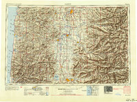
1954 Map of Salem
USGS Topo · Published 1954About this map
The Willamette River valley serves as the central artery of this mid-century landscape, connecting the capital at Salem to the growing hubs of Corvallis, Albany, and Eugene. The map illustrates a complex transportation network where the Southern Pacific RR and Oregon Electric Ry parallel the primary highway corridors of Us 99w and Us 99e. Beyond the fertile valley floor, the terrain rises sharply into the Coast Range to the west and the Cascade Range to the east, featuring landmarks like Marys Peak and the volcanic peak of Mount Jefferson. Water management and industrial development are evident in the presence of the Fern Ridge Reservoir and the Detroit Reservoir on the North Santiam R. From the timber-rich lands of the Siuslaw National Forest near Newport to the high alpine reaches of the Mount Hood National Forest, this survey documents the integration of Oregon's natural resources with its mid-1950s urban expansion.
Find a feature on this map
81 named features on this map. Tap any name to fly to it.
Don’t see what you’re looking for? This feature index may not catch every label — zoom into the map to look around manually.
Map Details
Editions of this 1954 Salem Map
This is the sole edition of this map. No revisions or reprints were ever made.
Other maps of this area
1909 · Harrisburg
USGS Topo · 1:31,680
1909 · Rowland
USGS Topo · 1:31,680
1909 · Elmira
USGS Topo · 1:62,500
1910 · Eugene
USGS Topo · 1:62,500
1911 · Brownsville
USGS Topo · 1:31,680
1911 · Lebanon
USGS Topo · 1:31,680
1911 · Monroe
USGS Topo · 1:31,680
1911 · Tangent
USGS Topo · 1:31,680
1911 · Inavale
USGS Topo · 1:31,680
1912 · Jefferson
USGS Topo · 1:31,680