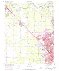
1969 Map of Salida
USGS Topo · Published 1977About this map
The Stanislaus River defines the northern boundary of this agricultural landscape, where the Southern Pacific railroad corridor drives the orientation of the valley's development. Centered on Salida, the map illustrates a region in transition as suburban expansion from Modesto pushes north across irrigation landmarks like the Main Canal and the Hetch Hetchy Aqueduct. The area is characterized by a dense network of educational and institutional sites, including Modesto Jr College, Modesto State Hospital, and several parochial schools such as St Stanislaus Sch. Local history is anchored by the Woodcolony Cem and rural school districts like Hart-Ransom Union Sch. Small-scale aviation and recreation also appear via the Flory Airstrip and the Spring Creek Golf and Country Club, while the presence of Sewage Disposal Ponds and an Agricultural Laboratory highlights the infrastructure required for the era's growing population centers.
Find a feature on this map
64 named features on this map. Tap any name to fly to it.
Don’t see what you’re looking for? This feature index may not catch every label — zoom into the map to look around manually.
Map Details
Editions of this 1969 Salida Map
4 editions found
Other maps of this area

1914 · Manteca
USGS Topo · 1:31,680

1914 · Avena
USGS Topo · 1:31,680

1915 · Ripon
USGS Topo · 1:31,680

1915 · Westport
USGS Topo · 1:31,680

1915 · Westley
USGS Topo · 1:31,680

1915 · Salida
USGS Topo · 1:31,680

1915 · Thalheim
USGS Topo · 1:31,680

1916 · Riverbank
USGS Topo · 1:31,680

1916 · Ceres
USGS Topo · 1:31,680

1939 · Modesto East
USGS Topo · 1:62,500