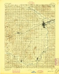
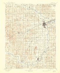
1892 Map of Salina
USGS Topo · Published 1897About this map
Salina serves as a major rail hub in the late nineteenth century, where the Union Pacific Railway and the Missouri Pacific Ry. converge. The landscape is defined by the winding courses of the Saline River and the Smoky Hill River, which support numerous small agricultural communities and river-adjacent townships. The map documents the dense grid of rural development across Saline and McPherson counties, noting landmarks like Soldier Cap Mound and Iron Mound. Settlements such as Lindsborg and Marquette anchor the southern portion of the sheet, while western outposts like Terra Cotta and Brookville sit along the primary westward rail line. This survey captures a specific moment of expansion when steam-powered transport dictated the growth of the central Kansas plains, connecting isolated prairie townships to the growing urban center at Salina.
Find a feature on this map
72 named features on this map. Tap any name to fly to it.
Don’t see what you’re looking for? This feature index may not catch every label — zoom into the map to look around manually.
Map Details
Editions of this 1892 Salina Map
6 editions found
Other maps of this area

1889 · Newton
USGS Topo · 1:125,000

1889 · Abilene
USGS Topo · 1:125,000

1891 · Hutchinson
USGS Topo · 1:125,000

1891 · Clay Center
USGS Topo · 1:125,000

1892 · Salina
USGS Topo · 1:125,000

1892 · Minneapolis
USGS Topo · 1:125,000

1893 · Hutchinson
USGS Topo · 1:125,000

1894 · Ellsworth
USGS Topo · 1:125,000

1894 · Newton
USGS Topo · 1:125,000

1894 · Abilene
USGS Topo · 1:125,000