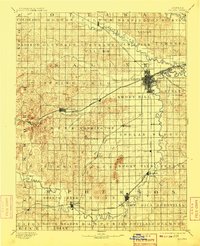
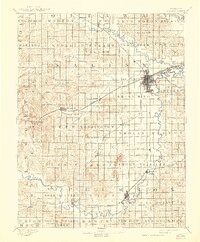
1892 Map of Salina
USGS Topo · Published 1909About this map
Salina serves as the central hub of this late nineteenth-century landscape, where a dense concentration of rail lines converge at the junction of the Union Pacific Railway, Atchison Topeka & Santa Fe Ry., and the Missouri Pacific Railway. This complex infrastructure reflects a period of rapid development across central Kansas, as the rail network follows the drainage of the Smoky Hill River and its numerous tributaries. To the south, the Swedish heritage of the Smoky Valley is evidenced by settlements like Lindsborg and Assaria. The terrain is punctuated by distinctive landmarks such as North Pole Mound, Iron Mound, and Soldier Cap Mound, which rise above the surrounding plains. Smaller outposts like Terra Cotta and Brookville along the western rail lines suggest the early-era ranching and shipping economies that defined the western reaches of the county during this survey period.
Find a feature on this map
76 named features on this map. Tap any name to fly to it.
Don’t see what you’re looking for? This feature index may not catch every label — zoom into the map to look around manually.
Map Details
Editions of this 1892 Salina Map
6 editions found
Other maps of this area

1889 · Newton
USGS Topo · 1:125,000

1889 · Abilene
USGS Topo · 1:125,000

1891 · Hutchinson
USGS Topo · 1:125,000

1891 · Clay Center
USGS Topo · 1:125,000

1892 · Salina
USGS Topo · 1:125,000

1892 · Minneapolis
USGS Topo · 1:125,000

1893 · Hutchinson
USGS Topo · 1:125,000

1894 · Ellsworth
USGS Topo · 1:125,000

1894 · Newton
USGS Topo · 1:125,000

1894 · Abilene
USGS Topo · 1:125,000