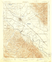
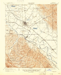
1912 Map of Salinas
USGS Topo · Published 1940About this map
Salinas serves as the focal point of this coastal valley landscape, where the agricultural footprint of Monterey County was firmly established by the early twentieth century. The map illustrates a complex network of land grants and ranchos, such as Llano de Buena Vista and Rincon del Zanjon, reflecting the area's transition from Spanish-Mexican land tenure to American industrial farming. The presence of the Pajaro Valley Consolidated R R and the Southern Pacific R R highlights the vital role of rail transport in moving crops from the fertile bottomlands toward larger markets. Along the Salinas River, the town of Spreckels stands as a notable industrial hub, while smaller communities like Natividad and Confederate Corners dot the alluvial plains. To the south and east, the elevation rises sharply toward Mt Toro and the Gabilan Range, where smaller canyons like Corral de Tierra Creek feed back into the valley floor.
Find a feature on this map
67 named features on this map. Tap any name to fly to it.
Don’t see what you’re looking for? This feature index may not catch every label — zoom into the map to look around manually.
Map Details
Editions of this 1912 Salinas Map
6 editions found
Other maps of this area

1910 · Gonzales
USGS Topo · 1:31,680

1910 · Salinas
USGS Topo · 1:31,680

1910 · Soledad
USGS Topo · 1:31,680

1912 · Salinas
USGS Topo · 1:62,500

1912 · Capitola
USGS Topo · 1:62,500

1913 · Monterey
USGS Topo · 1:62,500

1914 · Capitola
USGS Topo · 1:62,500

1915 · Soledad
USGS Topo · 1:62,500

1915 · San Juan Bautista
USGS Topo · 1:48,000

1917 · San Juan Bautista
USGS Topo · 1:62,500