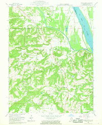
1959 Map of Saline Mines
USGS Topo · Published 1969About this map
Saline Mines and the surrounding river bluffs are documented here during a period of significant extraction within the Shawnee National Forest. The landscape is dominated by the confluence of the Saline River and the Ohio River, where industrial activity is evidenced by the complex of Maroning Mines and numerous individual sites like the Crystal Mine and Minerva Mine No 1. The map reveals a deeply etched terrain of hollows and ridges, such as Blind Hollow and Tucker Hill, which dictated the placement of early settlements and rural infrastructure.
Find a feature on this map
66 named features on this map. Tap any name to fly to it.
Don’t see what you’re looking for? This feature index may not catch every label — zoom into the map to look around manually.
Map Details
Editions of this 1959 Saline Mines Map
3 editions found
Other maps of this area

1916 · Shawneetown
USGS Topo · 1:62,500

1916 · Fords Ferry
USGS Topo · 1:62,500

1916 · Golconda
USGS Topo · 1:62,500

1916 · Equality
USGS Topo · 1:62,500

1920 · Goloonda
USGS Topo · 1:48,000

1921 · Fords Ferry
USGS Topo · 1:48,000

1921 · Golconda
USGS Topo · 1:62,500

1925 · Cave In Rock
USGS Topo · 1:62,500

1949 · Paducah
USGS Topo · 1:250,000

1950 · Paducah
USGS Topo · 1:250,000