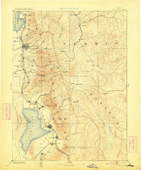
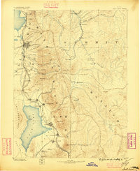
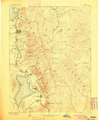
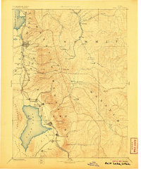
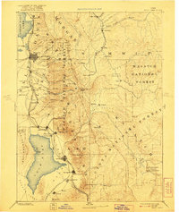
1885 Map of Salt Lake
USGS Topo · Published 1913About this map
Salt Lake City and the surrounding Wasatch front are captured in this reconnaissance survey, which reveals the early industrial and settlement patterns of northern Utah. The landscape is defined by the proximity of the Wasatch Mountains to the eastern shores of Utah Lake and the Great Salt Lake. A complex transportation network is already visible, featuring the Denver and Rio Grande Western R. R. and the Central Utah R. R., which linked growing agricultural hubs like Lehi, American Fork, and Spanish Fork. High in the mountains, mining activity is evidenced by Silver City and Alta, while the military presence at Fort Douglass stands guard over the territorial capital. To the east, the Heber Valley and Kamas Prairie support more isolated settlements, connected by the canyon passes that would shape the region's development for decades.
Find a feature on this map
85 named features on this map. Tap any name to fly to it.
Don’t see what you’re looking for? This feature index may not catch every label — zoom into the map to look around manually.
Map Details
Editions of this 1885 Salt Lake Map
7 editions found

Other maps of this area

1885 · Salt Lake
USGS Topo · 1:250,000

1885 · Manti
USGS Topo · 1:250,000

1885 · Sevier Desert
USGS Topo · 1:250,000

1885 · Uinta
USGS Topo · 1:250,000

1885 · Tooele Valley
USGS Topo · 1:250,000

1886 · Price River
USGS Topo · 1:250,000

1895 · Manti
USGS Topo · 1:250,000

1896 · Price River
USGS Topo · 1:250,000

1900 · Coalville
USGS Topo · 1:125,000
1901 · Hayden Peak
USGS Topo · 1:125,000