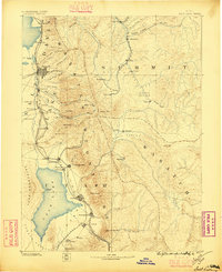
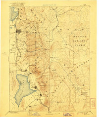
1885 Map of Salt Lake
USGS Topo · Published 1896About this map
The Wasatch Mountains dominate this late nineteenth-century survey, creating a sharp vertical divide between the burgeoning urban corridor of the Salt Lake Valley and the high-altitude mining and ranching districts to the east. Salt Lake City and Provo appear as established grid-iron hubs, connected by the Utah Central R. R. and the Denver and Rio Grande Western R. R., which skirt the eastern shore of Utah Lake. The map captures the era when heavy industry and extraction were transforming the landscape, visible in the high-mountain mining camps at Alta and Silver City. To the north and east, the Union Pacific R. R. follows the Weber River through Echo City, facilitating the movement of coal from Coalville and ores from Park City. This geography reveals a region transitioning from isolated agricultural settlements like Alpine and Kamas into a sophisticated industrial network driven by rail and mineral wealth.
Find a feature on this map
80 named features on this map. Tap any name to fly to it.
Don’t see what you’re looking for? This feature index may not catch every label — zoom into the map to look around manually.
Map Details
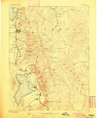
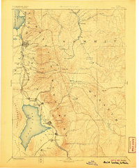
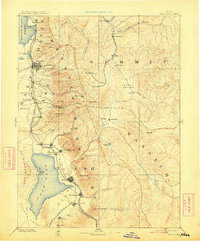
Editions of this 1885 Salt Lake Map
7 editions found

Other maps of this area

1885 · Salt Lake
USGS Topo · 1:250,000

1885 · Manti
USGS Topo · 1:250,000

1885 · Sevier Desert
USGS Topo · 1:250,000

1885 · Uinta
USGS Topo · 1:250,000

1885 · Tooele Valley
USGS Topo · 1:250,000

1886 · Price River
USGS Topo · 1:250,000

1895 · Manti
USGS Topo · 1:250,000

1896 · Price River
USGS Topo · 1:250,000

1900 · Coalville
USGS Topo · 1:125,000
1901 · Hayden Peak
USGS Topo · 1:125,000