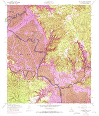
1954 Map of Salter Creek
USGS Topo · Published 1971About this map
The Sabine River meanders through this borderland, its course defining the boundary between Texas and Louisiana during a period of significant environmental transition. This 1954 survey, updated with 1969 photorevisions, captures the landscape just as the Toledo Bend Reservoir project began to alter the river valley. The eastern Louisiana side is dominated by the La Nana Grant and the settlement of Shinetown, while the Sabine National Forest covers much of the western Texas bank. Local history is deeply rooted in the small communities and rural religious sites like Pendleton Church, Beulah Church, and Harpers Chapel. Notable geographical features such as Goodlow Bluff and the sharp turn at Edison Camp Bend document the river's original character before inundation, while Negreet Bayou and Palo Gaucho Bayou feed into the main channel through dense bottomlands.
Find a feature on this map
34 named features on this map. Tap any name to fly to it.
Don’t see what you’re looking for? This feature index may not catch every label — zoom into the map to look around manually.
Map Details
Editions of this 1954 Salter Creek Map
2 editions found
Other maps of this area

1941 · Zwolle
USGS Topo · 1:62,500

1944 · Negreet
USGS Topo · 1:62,500

1944 · Patroon
USGS Topo · 1:62,500

1944 · Zwolle
USGS Topo · 1:62,500

1953 · Alexandria
USGS Topo · 1:250,000

1954 · Toro
USGS Topo · 1:24,000

1954 · Columbus
USGS Topo · 1:24,000
1954 · Negreet
USGS Topo · 1:24,000

1954 · Negreet
USGS Topo · 1:62,500

1954 · Salter Creek
USGS Topo · 1:24,000