
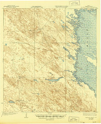
1923 Map of Saltillo Ranch
USGS Topo · Published 1923About this map
The vast ranching country of South Texas is captured here in the early 1920s, a period when the landscape was defined by isolated outposts and vital water sources. The map centers on the namesake Saltillo Ranch and other established homesteads like San Pedro Ranch and San Ignacio Ranch. These hubs were connected by a network of trails across a terrain of subtle elevation changes and sandy dunes, where the location of deep wells provided the only reliable water for cattle and residents. To the east, the shoreline meets the shallow waters of the Laguna Madre, showing the intricate boundary between the mainland and the tidal flats near Lopena Island. The survey, conducted just after the war, documents these working ranch lands before modern infrastructure fundamentally altered the traditional patterns of the Kenedy County interior.
Find a feature on this map
12 named features on this map. Tap any name to fly to it.
Don’t see what you’re looking for? This feature index may not catch every label — zoom into the map to look around manually.
Map Details
Editions of this 1923 Saltillo Ranch Map
2 editions found
Other maps of this area

1921 · Tarida Ranch
USGS Topo · 1:62,500

1922 · La Sal Vieja
USGS Topo · 1:62,500

1923 · Armstrong
USGS Topo · 1:62,500

1923 · Lopena Island
USGS Topo · 1:62,500

1928 · Sarita
USGS Topo · 1:125,000

1950 · Corpus Christi
USGS Topo · 1:250,000

1951 · Potrero Lopeno NW
USGS Topo · 1:24,000

1952 · Potrero Cortado
USGS Topo · 1:24,000

1952 · South of Potrero Lopeno NW
USGS Topo · 1:24,000

1952 · Sarita 4 SE
USGS Topo · 1:24,000