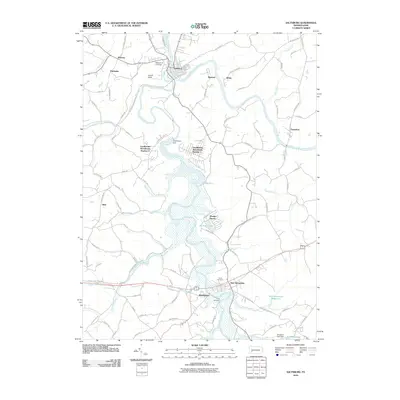
2010 Map of Saltsburg
USGS Topo · Published 2010About this map
Saltsburg sits at the confluence of the Conemaugh River and the Kiskiminetas River, serving as a central hub in this western Pennsylvania landscape. The region's geography is defined by significant water management and recreation areas, most notably the Loyalhanna Dam and the expansive waters behind it. The map details several residential pockets, including Loyalhanna Woodlands Number 1 and Loyalhanna Woodlands Number 2, which are situated near the reservoir's north end. To the south, the settlement of New Alexandria is flanked by the New Alexandria Reservoir and provides access to local landmarks like Union Cemetery. The presence of the Slybac E O C Airport near Wakena and the industrial-named Moween suggests a history of varied land use, from small-scale aviation to local industry, all tied together by a network of rural roads like Tunnelton Rd and Saltsburg Rd.
Find a feature on this map
91 named features on this map. Tap any name to fly to it.
Don’t see what you’re looking for? This feature index may not catch every label — zoom into the map to look around manually.
Map Details
Editions of this 2010 Saltsburg Map
This is the sole edition of this map. No revisions or reprints were ever made.
Other maps of this area

1900 · Latrobe
USGS Topo · 1:62,500

1902 · Latrobe
USGS Topo · 1:62,500

1902 · Elders Ridge
USGS Topo · 1:62,500

1903 · Latrobe
USGS Topo · 1:62,500

1904 · Elders Ridge
USGS Topo · 1:62,500

1904 · Greensburg
USGS Topo · 1:62,500

1906 · Greensburg
USGS Topo · 1:62,500

1907 · Freeport
USGS Topo · 1:62,500

1909 · Freeport
USGS Topo · 1:62,500

1953 · Pittsburgh
USGS Topo · 1:250,000
Featured Places
- White, Conemaugh Township
- Saltsburg, PA
- New Alexandria, Derry Township
- Salem Township, PA
- Derry Township, PA