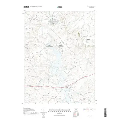
2019 Map of Saltsburg
USGS Topo · Published 2019About this map
Saltsburg serves as a focal point at the confluence of the Conemaugh River and Loyalhanna Creek, where they join to form the Kiskiminetas River. This modern survey documents the intricate geography along the Westmoreland and Indiana County line, showing a landscape defined by sharp river bends and residential developments like Loyalhanna Woodlands Number 1 and Manitto Haven. Local history is deeply embedded in the terrain, evidenced by numerous burial sites including Old Saltsburg Cem, Saint Matthew's Cem, and Edgewood Cem. To the south, the village of New Alexandria sits near the New Alexandria Reservoir and the historic Old William Penn Hwy. The map details how transportation corridors like US Highway 22 and several state routes navigate the winding waterways and elevated points such as Locust Knob.
Find a feature on this map
134 named features on this map. Tap any name to fly to it.
Don’t see what you’re looking for? This feature index may not catch every label — zoom into the map to look around manually.
Map Details
Editions of this 2019 Saltsburg Map
This is the sole edition of this map. No revisions or reprints were ever made.
Other maps of this area

1900 · Latrobe
USGS Topo · 1:62,500

1902 · Latrobe
USGS Topo · 1:62,500

1902 · Elders Ridge
USGS Topo · 1:62,500

1903 · Latrobe
USGS Topo · 1:62,500

1904 · Elders Ridge
USGS Topo · 1:62,500

1904 · Greensburg
USGS Topo · 1:62,500

1906 · Greensburg
USGS Topo · 1:62,500

1907 · Freeport
USGS Topo · 1:62,500

1909 · Freeport
USGS Topo · 1:62,500

1953 · Pittsburgh
USGS Topo · 1:250,000
Featured Places
- White, Conemaugh Township
- Saltsburg, PA
- New Alexandria, Derry Township
- Salem Township, PA
- Derry Township, PA