1952 Map of Samsula
USGS Topo · Published 1993About this map
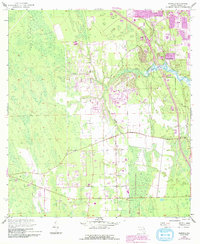
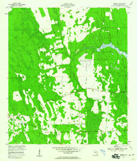
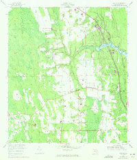
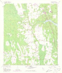
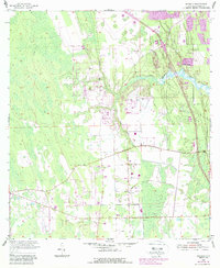
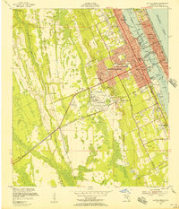
Samsula and the southwestern fringes of Port Orange define the human landscape of this Volusia County survey, which reveals a transition between established agricultural settlements and burgeoning coastal development. The meandering path of Spruce Creek flows toward the east, surrounded by the extensive Spruce Creek Swamp and the distinct elevation of Long Island. This 1952 document, updated with 1990s revisions, captures the infrastructure of the era, including the Samsula Canal and the Spruce Creek Airport. Educational centers like Spruce Creek High Sch. and Horizon Sch. indicate the residential growth reaching into the interior. The presence of several Borrow Pits and a Spoil Bank suggests the ongoing modification of the Florida wetlands for transport and drainage, providing a clear view of how the land was managed before the rapid modern expansion of the Atlantic coast.
Find a feature on this map
14 named features on this map. Tap any name to fly to it.
Don’t see what you’re looking for? This feature index may not catch every label — zoom into the map to look around manually.
Map Details
Editions of this 1952 Samsula Map
6 editions found
Other maps of this area

1937 · Port Orange
USGS Topo · 1:48,000

1943 · Port Orange
USGS Topo · 1:62,500
1944 · Port Orange
USGS Topo · 1:62,500
1950 · Edgewater
USGS Topo · 1:24,000
1952 · Samsula
USGS Topo · 1:24,000
1952 · Daytona Beach
USGS Topo · 1:24,000

1954 · Daytona Beach
USGS Topo · 1:250,000

1955 · Orlando
USGS Topo · 1:250,000
1956 · Port Orange
USGS Topo · 1:24,000
1956 · New Smyrna Beach
USGS Topo · 1:24,000