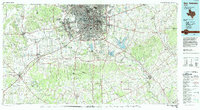
1954 Map of San Antonio
USGS Topo · Published 1964This historical map portrays the area of San Antonio in 1954, primarily covering Bexar County as well as portions of Wilson County, Atascosa County, Edwards County, Kendall County, Karnes County, Hays County, Blanco County, Guadalupe County, Zavala County, Comal County, Uvalde County, Bandera County, Frio County, Kerr County, Real County, and Medina County. Featuring a scale of 1:250000, this map provides a highly detailed snapshot of the terrain, roads, buildings, counties, and historical landmarks in the San Antonio region at the time. Published in 1964, it is one of 3 known editions of this map due to revisions or reprints.
Find a feature on this map
152 named features on this map. Tap any name to fly to it.
Don’t see what you’re looking for? This feature index may not catch every label — zoom into the map to look around manually.
Map Details
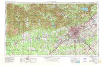
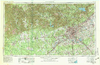
Editions of this 1954 San Antonio Map
3 editions found
Historical Maps of Woodrow Through Time
3 maps found