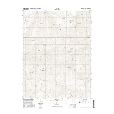
2017 Map of San Arroyo Ridge
USGS Topo · Published 2017About this map
San Arroyo Ridge and the Book Cliffs dominate this portion of the East Desert, where the high-altitude terrain of the Bookcliffs meets the complex drainage systems of the Colorado River basin. The landscape is defined by its deep canyons and prominent ridges, including Tom Patterson Ridge and Black Horse Ridge. The presence of industrial activity is visible through several resource extraction points, such as E Canyon Wells 1, E Canyon Wells 2, and San Arroyo Ridge Wells. Transport across this difficult geography is facilitated by the Bookcliff Ridge Rd and E Canyon Rd, which follow the natural contours of the high ground. In the southeast, the headwaters of Bitter Cr and its various forks, such as the Middle Fork Bitter Cr, carve through the eastern slopes of the ridge system.
Find a feature on this map
43 named features on this map. Tap any name to fly to it.
Don’t see what you’re looking for? This feature index may not catch every label — zoom into the map to look around manually.
Map Details
Editions of this 2017 San Arroyo Ridge Map
This is the sole edition of this map. No revisions or reprints were ever made.
Other maps of this area

1885 · East Tavaputs
USGS Topo · 1:250,000

1956 · Grand Junction
USGS Topo · 1:250,000

1959 · Grand Junction
USGS Topo · 1:250,000

1960 · Grand Junction
USGS Topo · 1:250,000

1962 · Grand Junction
USGS Topo · 1:250,000

1964 · Grand Junction
USGS Topo · 1:250,000

1965 · Grand Junction
USGS Topo · 1:250,000

1966 · Seep Canyon
USGS Topo · 1:24,000

1966 · Tom Patterson Canyon
USGS Topo · 1:24,000
1966 · Rat Hole Ridge
USGS Topo · 1:24,000