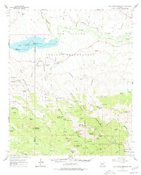
1962 Map of San Carlos Reservoir
USGS Topo · Published 1977About this map
The San Carlos Indian Reservation dominates this landscape, showing the convergence of the Gila River and the San Carlos River at the San Carlos Reservoir. This era of the reservation's history is marked by a transition from traditional river-valley use to a more industrial and ranching-focused economy. Traces of previous infrastructure are visible in the Southern Pacific RR Grade and an Old RR Grade that snake along the river banks.
Find a feature on this map
108 named features on this map. Tap any name to fly to it.
Don’t see what you’re looking for? This feature index may not catch every label — zoom into the map to look around manually.
Map Details
Editions of this 1962 San Carlos Reservoir Map
3 editions found

Other maps of this area

1911 · Winkelman
USGS Topo · 1:125,000

1913 · Winkelman
USGS Topo · 1:125,000

1915 · Christmas
USGS Topo · 1:62,500

1917 · Christmas
USGS Topo · 1:62,500

1938 · Klondyke
USGS Topo · 1:48,000

1943 · Klondyke
USGS Topo · 1:62,500

1944 · Jackson Mtn.
USGS Topo · 1:62,500

1946 · Jackson Mtn.
USGS Topo · 1:62,500

1949 · Holy Joe Peak
USGS Topo · 1:62,500

1949 · Brandenburg Mtn
USGS Topo · 1:24,000