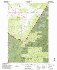
1994 Map of Sanders
USGS Topo · Published 1997About this map
The settlement of Sanders serves as a small hub in this north Idaho landscape, where the northern border of the Coeur D'Alene Indian Reservation meets the vast timberlands of the St Joe National Forest. This 1994 revision, based on 1980s and 1990s aerial photography, captures a complex boundary region where the Benewah and Latah County line intersects with protected lands. Along the western edge, the Mary Minerva Mc Croskey Memorial State Park traces the ridge lines, providing a contrast to the industrial logging and resource extraction implied by the Gravel Pit near the headwaters of Hangman Creek. The topography is defined by prominent high points like Prospect Peak and Holaki Knob, which overlook a network of drainages including Mineral Creek and Smith Creek. These watercourses reveal the rugged drainage patterns that historically dictated movement and land use across the Idaho Panhandle's forested interior.
Find a feature on this map
27 named features on this map. Tap any name to fly to it.
Don’t see what you’re looking for? This feature index may not catch every label — zoom into the map to look around manually.
Map Details
Editions of this 1994 Sanders Map
2 editions found
Other maps of this area

1955 · Pullman
USGS Topo · 1:250,000

1955 · Spokane
USGS Topo · 1:250,000

1957 · Emida
USGS Topo · 1:62,500

1957 · Tensed
USGS Topo · 1:62,500

1958 · Spokane
USGS Topo · 1:250,000

1958 · Pullman
USGS Topo · 1:250,000

1960 · Potlatch
USGS Topo · 1:62,500

1961 · Deary
USGS Topo · 1:62,500

1981 · St Maries
USGS Topo · 1:100,000

1981 · Potlatch
USGS Topo · 1:100,000