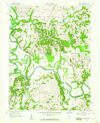
1958 Map of Sandy Hook
USGS Topo · Published 1960About this map
The confluence of the West Fork White River and East Fork White River dominates this southwestern Indiana landscape. These winding waterways define the boundaries between Daviess, Knox, and Pike counties, creating a complex network of oxbow lakes and backwaters such as Jackson Pond, Wander Pond, Horseshoe Pond, and Chew Pond. The terrain reflects a traditional rural settlement pattern centered on local institutions, evidenced by several small schools including Letts Sch, Scudder Sch, and Whittier Sch. Scattered across the townships of Veale, Washington, and Harrison, numerous rural churches and their associated cemeteries, such as Bethel Church and Anderson Chapel Cemetery, serve as key markers for genealogical research. A single Strip Mine in the southern portion of the sheet points to the region's industrial activity during the late 1950s.
Find a feature on this map
41 named features on this map. Tap any name to fly to it.
Don’t see what you’re looking for? This feature index may not catch every label — zoom into the map to look around manually.
Map Details
Editions of this 1958 Sandy Hook Map
Other maps of this area

1902 · Ditney
USGS Topo · 1:125,000

1903 · Velpen
USGS Topo · 1:62,500

1903 · Petersburg
USGS Topo · 1:62,500

1944 · Montgomery
USGS Topo · 1:24,000

1944 · Glendale
USGS Topo · 1:24,000

1944 · Washington
USGS Topo · 1:24,000

1944 · Monroe City
USGS Topo · 1:24,000

1944 · Wheatland
USGS Topo · 1:24,000

1945 · Sandy Hook
USGS Topo · 1:24,000

1956 · Vincennes
USGS Topo · 1:250,000