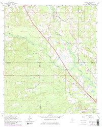
1965 Map of Sanford
USGS Topo · Published 1982About this map
Sanford and the surrounding piney woods landscape are defined by the convergence of major southern Mississippi waterways. This survey captures a rural landscape where Okatoma Creek and Bowie Creek meander through complex bottomlands before reaching the Bowie River at Rawls Springs. The terrain is marked by numerous family burial grounds, including Watts Cem and Bryant Cem, which provide essential touchpoints for genealogical research in this multi-county junction of Covington, Lamar, Forrest, and Jones counties.
Find a feature on this map
29 named features on this map. Tap any name to fly to it.
Don’t see what you’re looking for? This feature index may not catch every label — zoom into the map to look around manually.
Map Details
Editions of this 1965 Sanford Map
3 editions found
Other maps of this area

1953 · Hattiesburg
USGS Topo · 1:250,000

1958 · Hattiesburg
USGS Topo · 1:250,000

1964 · Seminary
USGS Topo · 1:24,000

1964 · Hattiesburg
USGS Topo · 1:24,000

1965 · Hattiesburg SW
USGS Topo · 1:24,000

1965 · Eastabuchie
USGS Topo · 1:24,000

1965 · Moselle
USGS Topo · 1:24,000

1965 · Sanford
USGS Topo · 1:24,000

1974 · Sumrall
USGS Topo · 1:24,000

1974 · Oloh
USGS Topo · 1:24,000