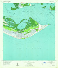
1958 Map of Sanibel
USGS Topo · Published 1962About this map
Sanibel Island and the southern tip of Pine Island dominate this late 1950s survey of Lee County's coastal waters. The landscape is defined by the intricate relationship between land and sea, featuring the protected waters of Tarpon Bay and the narrow passage of the Short Cutoff. On the eastern tip of Sanibel, Point Ybel serves as a critical maritime landmark, home to the Sanibel Island Lighthouse and a concentration of local infrastructure including the Sanibel Sch and Sanibel Cem.
Find a feature on this map
37 named features on this map. Tap any name to fly to it.
Don’t see what you’re looking for? This feature index may not catch every label — zoom into the map to look around manually.
Map Details
Editions of this 1958 Sanibel Map
4 editions found
Other maps of this area

1956 · West Palm Beach
USGS Topo · 1:250,000

1956 · Tampa
USGS Topo · 1:250,000

1956 · Charlotte Harbor
USGS Topo · 1:250,000

1957 · West Palm Beach
USGS Topo · 1:250,000

1958 · West Palm Beach
USGS Topo · 1:250,000

1958 · Captiva
USGS Topo · 1:24,000

1958 · Fort Myers SW
USGS Topo · 1:24,000

1958 · Sanibel
USGS Topo · 1:24,000

1958 · Pine Island Center
USGS Topo · 1:24,000
1958 · Wulfert
USGS Topo · 1:24,000
Featured Places
- Sanibel, FL
- Saint James City, FL
- Punta Rassa, FL
- Shangri-La Mobile Home Park, FL
- Saint James Mobile Home Park, FL