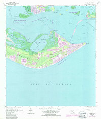
1958 Map of Sanibel
USGS Topo · Published 1988About this map
Sanibel Island and the surrounding waters of San Carlos Bay are captured here during a period of significant growth and conservation. While the J N (Ding) Darling National Wildlife Refuge preserves the mangrove-lined interior around Tarpon Bay, residential development is visible expanding near Dixie Beach and the Sanibel Corporate Boundary. The map shows essential local landmarks including the Sanibel Sch, a Landing Strip, and a Flowing Well near the center of the island.
Find a feature on this map
43 named features on this map. Tap any name to fly to it.
Don’t see what you’re looking for? This feature index may not catch every label — zoom into the map to look around manually.
Map Details
Editions of this 1958 Sanibel Map
4 editions found
Other maps of this area

1956 · West Palm Beach
USGS Topo · 1:250,000

1956 · Tampa
USGS Topo · 1:250,000

1956 · Charlotte Harbor
USGS Topo · 1:250,000

1957 · West Palm Beach
USGS Topo · 1:250,000

1958 · West Palm Beach
USGS Topo · 1:250,000

1958 · Captiva
USGS Topo · 1:24,000

1958 · Fort Myers SW
USGS Topo · 1:24,000

1958 · Sanibel
USGS Topo · 1:24,000

1958 · Pine Island Center
USGS Topo · 1:24,000
1958 · Wulfert
USGS Topo · 1:24,000
Featured Places
- Sanibel, FL
- Saint James City, FL
- Punta Rassa, FL
- Shangri-La Mobile Home Park, FL
- Saint James Mobile Home Park, FL