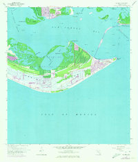
1958 Map of Sanibel
USGS Topo · Published 1973About this map
Sanibel Island appears in a moment of transition, balancing its wild origins with mid-century development. The J N Ding Darling National Wildlife Refuge dominates the interior, preserving the complex network of the Sanibel Bayou and Tarpon Bay. Along the eastern shore, the village of Sanibel shows early residential expansion, supported by local landmarks like the Sanibel Sch and the historic Sanibel Island Lighthouse at Point Ybel. To the north, St James City sits at the tip of Pine Island, separated from the mainland by the waters of San Carlos Bay. The presence of a Landing Field and a Toll road leading toward Punta Rassa reflects the evolving accessibility of the island before it became the modern destination known today.
Find a feature on this map
36 named features on this map. Tap any name to fly to it.
Don’t see what you’re looking for? This feature index may not catch every label — zoom into the map to look around manually.
Map Details
Editions of this 1958 Sanibel Map
4 editions found
Other maps of this area

1956 · West Palm Beach
USGS Topo · 1:250,000

1956 · Tampa
USGS Topo · 1:250,000

1956 · Charlotte Harbor
USGS Topo · 1:250,000

1957 · West Palm Beach
USGS Topo · 1:250,000

1958 · West Palm Beach
USGS Topo · 1:250,000

1958 · Captiva
USGS Topo · 1:24,000

1958 · Fort Myers SW
USGS Topo · 1:24,000

1958 · Sanibel
USGS Topo · 1:24,000

1958 · Pine Island Center
USGS Topo · 1:24,000
1958 · Wulfert
USGS Topo · 1:24,000
Featured Places
- Sanibel, FL
- Saint James City, FL
- Punta Rassa, FL
- Shangri-La Mobile Home Park, FL
- Saint James Mobile Home Park, FL