
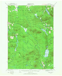
1921 Map of Santa Clara
USGS Topo · Published 1960About this map
Santa Clara serves as a central hub in this Franklin County landscape, where the New York Central RR and the Brooklyn Cooperage RR meet along the Deer River. The region is defined by its industrial and recreational character within the Adirondack Park, featuring isolated settlements like Everton and Reynoldston alongside numerous logging or service rails. Further south, the map reveals a network of high-elevation peaks including Jennings Mtn and Blue Mtn, the latter hosting the Blue Mtn House. The presence of several numbered schoolhouses, such as School No 25 and McCollom School, points to a distributed rural population during this era. Large water bodies like Lake Titus and Lake Duane anchor the northeastern sections, while the interior is a dense maze of ponds and swamps, such as Jennings Swamp and Madawaska Pond, illustrating the complex drainage patterns of the Northern Adirondacks.
Find a feature on this map
128 named features on this map. Tap any name to fly to it.
Don’t see what you’re looking for? This feature index may not catch every label — zoom into the map to look around manually.
Map Details
Editions of this 1921 Santa Clara Map
2 editions found
Other maps of this area

1902 · Saranac
USGS Topo · 1:62,500

1904 · Saranac
USGS Topo · 1:62,500

1905 · Saint Regis
USGS Topo · 1:62,500

1906 · Loon Lake
USGS Topo · 1:62,500

1908 · Loon Lake
USGS Topo · 1:62,500

1915 · Chateaugay
USGS Topo · 1:62,500

1915 · Malone
USGS Topo · 1:62,500

1915 · Moira
USGS Topo · 1:62,500

1917 · Malone
USGS Topo · 1:62,500

1917 · Moira
USGS Topo · 1:62,500