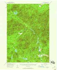
1953 Map of Santanoni
USGS Topo · Published 1959About this map
Tahawus and the industrial activity near the Old MacIntyre Furnace anchor the southern portion of this mid-century survey, illustrating the persistence of mining and early iron production in the Adirondacks. The presence of a Strip Mine and the Delaware And Hudson rail line near Sanford Hill highlights the era's extraction economy, contrasting with the wilderness to the north. Trekkers and historians can trace the Northville Placid Trail as it winds through the Santanoni Mountains and past the Big Eddy on the Cold River. The map also captures several high peaks and geological landmarks, including the sheer walls of Indian Pass and the Lookout Tower atop Mount Adams. From the settlement of Averyville in the north to the remote Duck Hole, the landscape is a complex network of glacial ponds, mountain ranges, and historic timber and mining outposts.
Find a feature on this map
100 named features on this map. Tap any name to fly to it.
Don’t see what you’re looking for? This feature index may not catch every label — zoom into the map to look around manually.
Map Details
Editions of this 1953 Santanoni Map
5 editions found

Other maps of this area

1895 · Mt. Marcy
USGS Topo · 1:62,500

1896 · Lake Placid
USGS Topo · 1:62,500

1897 · Schroon Lake
USGS Topo · 1:62,500

1898 · Newcomb
USGS Topo · 1:62,500

1898 · Lake Placid
USGS Topo · 1:62,500

1901 · Newcomb
USGS Topo · 1:62,500

1902 · Mt. Marcy
USGS Topo · 1:62,500

1902 · Saranac
USGS Topo · 1:62,500

1903 · Blue Mountain
USGS Topo · 1:62,500

1904 · Saranac
USGS Topo · 1:62,500