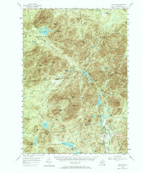
1953 Map of Santanoni
USGS Topo · Published 1967About this map
The high peaks and remote watersheds of the Adirondack State Park dominate this mid-century survey, centered on the Santanoni Mountains and the headwaters of the Hudson River. The settlement at Tahawus and the nearby Old MacNaughton Furnace reflect the region's industrial heritage, linked to an Iron Mine situated near Sanford Hill. This landscape is defined by its network of historic trails and remote waters, including the Northville Placid trail which winds through the central wilderness.
Find a feature on this map
108 named features on this map. Tap any name to fly to it.
Don’t see what you’re looking for? This feature index may not catch every label — zoom into the map to look around manually.
Map Details
Editions of this 1953 Santanoni Map
5 editions found

Other maps of this area

1895 · Mt. Marcy
USGS Topo · 1:62,500

1896 · Lake Placid
USGS Topo · 1:62,500

1897 · Schroon Lake
USGS Topo · 1:62,500

1898 · Newcomb
USGS Topo · 1:62,500

1898 · Lake Placid
USGS Topo · 1:62,500

1901 · Newcomb
USGS Topo · 1:62,500

1902 · Mt. Marcy
USGS Topo · 1:62,500

1902 · Saranac
USGS Topo · 1:62,500

1903 · Blue Mountain
USGS Topo · 1:62,500

1904 · Saranac
USGS Topo · 1:62,500