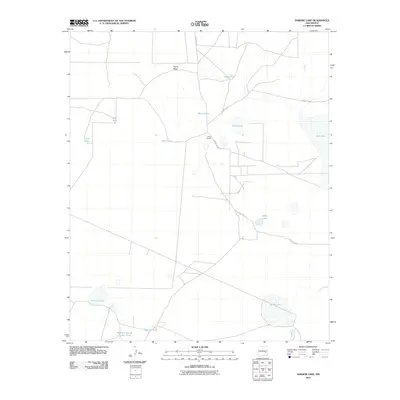
2010 Map of Sardine Lake
USGS Topo · Published 2010About this map
The arid landscape of Chaves County is defined here by an extensive system of water management features and cattle ranching infrastructure. Palma Mesa rises in the northern portion of the quadrangle, overlooking a network of earthen tanks and basins essential for livestock in this high-desert environment. The namesake Sardine Lake and the larger Adobe Lake anchor the southern reaches, while the eastern edge is marked by the expansive Red Lake. This 2010 survey illustrates the continued reliance on isolated ranching outposts like O'Brien Ranch, which sits at the junction of rural tracks. The presence of whimsically named features such as Madison Square Garden Tank alongside more traditional landmarks like Deep Lake and Twin Lakes reveals the local character of land use. Transportation is limited to a few arterial routes, specifically County Rd-50 and County Rd-49, which connect these remote water sources and grazing lands.
Find a feature on this map
17 named features on this map. Tap any name to fly to it.
Don’t see what you’re looking for? This feature index may not catch every label — zoom into the map to look around manually.
Map Details
Editions of this 2010 Sardine Lake Map
This is the sole edition of this map. No revisions or reprints were ever made.
Other maps of this area

1949 · Sardine Mountain
USGS Topo · 1:24,000

1949 · L-E Ranch
USGS Topo · 1:24,000

1954 · Brownfield
USGS Topo · 1:250,000

1955 · Roswell
USGS Topo · 1:250,000

1958 · Brownfield
USGS Topo · 1:250,000

1958 · Roswell
USGS Topo · 1:250,000

1962 · Roswell
USGS Topo · 1:250,000

1962 · Brownfield
USGS Topo · 1:250,000
1967 · Campbell
USGS Topo · 1:24,000

1967 · Haystack Mountain
USGS Topo · 1:24,000