
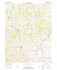
1952 Map of Sardis
USGS Topo · Published 1953About this map
Sardis and Abigail sit within a deeply dissected plateau where the North Fork Licking River carves through the landscape at the intersection of Mason, Bracken, and Robertson counties. This 1950s-era topography reveals a rural society structured around ridge-top roads and creek-valley drainages, with small country churches such as Salem Ch and Union Ch serving as focal points for the surrounding farmsteads. The intricate drainage network, including Shannon Creek, Wolf Creek, and Two Lick Creek, dictates the placement of early settlements and transportation routes. Genealogists may find particular value in the scattered Cem markers and spiritual centers like Bethel Ch and Shannon Ch, which anchor the local history of these upland Kentucky communities.
Find a feature on this map
20 named features on this map. Tap any name to fly to it.
Don’t see what you’re looking for? This feature index may not catch every label — zoom into the map to look around manually.
Map Details
Editions of this 1952 Sardis Map
2 editions found
Other maps of this area

1915 · Maysville
USGS Topo · 1:62,500

1919 · Maysville
USGS Topo · 1:62,500

1952 · Cowan
USGS Topo · 1:24,000

1952 · Germantown
USGS Topo · 1:24,000

1952 · Elizaville
USGS Topo · 1:24,000

1952 · Maysville West
USGS Topo · 1:24,000

1952 · Mount Olivet
USGS Topo · 1:24,000

1952 · Piqua
USGS Topo · 1:24,000
1952 · Mays Lick
USGS Topo · 1:24,000

1952 · Brooksville
USGS Topo · 1:24,000