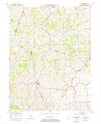
1952 Map of Sardis
USGS Topo · Published 1978About this map
Sardis serves as a primary settlement point in this rural landscape where Mason, Robertson, and Bracken counties meet. The terrain is defined by the winding course of the North Fork Licking River and its numerous tributaries, including Two Lick Creek and Shannon Creek. This 1952 field check, later updated in the 1970s, reveals a community-focused geography anchored by rural houses of worship such as Salem Ch, Union Ch, and Bethel Ch. Small hamlets like Abigail and the scattered crossroads of Shannon Ch are linked by a network of local roads that follow the ridges and creek valleys. The intricate water system, featuring names like Whippoorwill Branch and Rag Lick Creek, illustrates the traditional drainage patterns that shaped local property lines and agricultural boundaries during the mid-20th century.
Find a feature on this map
23 named features on this map. Tap any name to fly to it.
Don’t see what you’re looking for? This feature index may not catch every label — zoom into the map to look around manually.
Map Details
Editions of this 1952 Sardis Map
2 editions found
Other maps of this area

1915 · Maysville
USGS Topo · 1:62,500

1919 · Maysville
USGS Topo · 1:62,500

1952 · Cowan
USGS Topo · 1:24,000

1952 · Germantown
USGS Topo · 1:24,000

1952 · Elizaville
USGS Topo · 1:24,000

1952 · Maysville West
USGS Topo · 1:24,000

1952 · Sardis
USGS Topo · 1:24,000

1952 · Mount Olivet
USGS Topo · 1:24,000

1952 · Piqua
USGS Topo · 1:24,000
1952 · Mays Lick
USGS Topo · 1:24,000