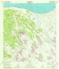
1951 Map of Sarita 4 NE
USGS Topo · Published 1978About this map
The northern shoreline of Baffin Bay meets a landscape of shifting sand dunes in this detailed survey of Kenedy County. The region is defined by its reliance on subterranean water, evidenced by a dense network of named water sources including Santiago Artesian Well, Mota Negra Artesian Well, and Pasadizo Artesian Well. These wells, often associated with specific ranching operations or family names, provided the lifeblood for isolated settlements like Los Corrallos in a terrain otherwise dominated by sand and mud flats. Along the coast, Black Bluff stands as a prominent topographical feature overlooking the bay. The map illustrates the specialized infrastructure of South Texas coastal plains, where artesian wells like Tio Chon Well and Pazita Well were critical for livestock and human habitation amidst the moving sands of the Wild Horse Desert.
Find a feature on this map
17 named features on this map. Tap any name to fly to it.
Don’t see what you’re looking for? This feature index may not catch every label — zoom into the map to look around manually.
Map Details
Editions of this 1951 Sarita 4 NE Map
3 editions found
Other maps of this area

1928 · Sarita
USGS Topo · 1:125,000

1950 · Corpus Christi
USGS Topo · 1:250,000

1951 · Point Of Rocks
USGS Topo · 1:24,000

1951 · Kleberg Point
USGS Topo · 1:24,000

1951 · Sarita 4 NE
USGS Topo · 1:24,000

1951 · South Bird Island
USGS Topo · 1:62,500

1952 · Potrero Cortado
USGS Topo · 1:24,000

1952 · Riviera Beach
USGS Topo · 1:24,000

1952 · La Parra Ranch
USGS Topo · 1:24,000

1952 · Yarborough Pass
USGS Topo · 1:24,000