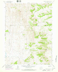
1962 Map of Sawtooth Mountain
USGS Topo · Published 1979About this map
Bear River Divide dominates the central landscape of this western Wyoming survey, serving as a prominent geographical boundary between the drainages of the North Fork Bear River and the complex creek systems to the west. The terrain is defined by high ridges and peaks such as Sawtooth Mtn, North Sheep Mtn, and the distinctive Pinnacle. This area straddles the Lincoln and Uinta County line, documenting a high-altitude wilderness used for seasonal transit as evidenced by a network of Pack Trails and Jeep Trails. To the southwest, The Hogback and Red Eye Basin reflect the erosion-carved character of the Session Mountains. While largely undeveloped, a lone Mine and various sheep-related landmarks suggest the 1960s-era land use focused on resource extraction and high-country grazing.
Find a feature on this map
23 named features on this map. Tap any name to fly to it.
Don’t see what you’re looking for? This feature index may not catch every label — zoom into the map to look around manually.
Map Details
Editions of this 1962 Sawtooth Mountain Map
3 editions found
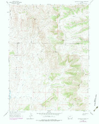
Other maps of this area

1912 · Randolph
USGS Topo · 1:125,000

1954 · Ogden
USGS Topo · 1:250,000

1958 · Ogden
USGS Topo · 1:250,000

1960 · Ogden
USGS Topo · 1:250,000

1962 · Bell Butte NE
USGS Topo · 1:24,000

1962 · Sawtooth Mountain
USGS Topo · 1:24,000

1962 · Windy Point
USGS Topo · 1:24,000

1962 · Bell Butte
USGS Topo · 1:24,000

1965 · Little Dee Creek
USGS Topo · 1:24,000

1965 · Three Forks
USGS Topo · 1:24,000