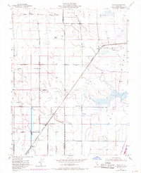
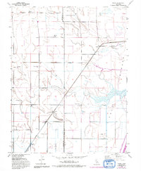
1952 Map of Saxon
USGS Topo · Published 1969About this map
Agricultural life in the Sacramento Valley defines this landscape, where the Sacramento Northern railroad cuts a diagonal line through the heart of the region. The map highlights a series of established estates and local nodes, including Glide Ranch, Maxwell Ranch, and the small settlement at Saxon. To the east, the massive engineering of the Yolo By-Pass dominates the terrain, designed to manage seasonal overflow from the river systems. Near the northern boundary, the Military Reservation sits adjacent to the Tremont Cem, indicating a long-standing community presence.
Find a feature on this map
27 named features on this map. Tap any name to fly to it.
Don’t see what you’re looking for? This feature index may not catch every label — zoom into the map to look around manually.
Map Details
Editions of this 1952 Saxon Map
5 editions found
Other maps of this area

1907 · Woodland
USGS Topo · 1:62,500

1907 · Davisville
USGS Topo · 1:62,500

1908 · Vacaville
USGS Topo · 1:62,500

1908 · Courtland
USGS Topo · 1:62,500

1915 · Swingle
USGS Topo · 1:31,680

1915 · Merritt
USGS Topo · 1:31,680

1916 · Dixon
USGS Topo · 1:31,680

1916 · Cache Slough
USGS Topo · 1:31,680
1916 · Lovdal
USGS Topo · 1:31,680

1916 · Vorden
USGS Topo · 1:31,680