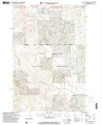
1997 Map of Scairt Woman Draw
USGS Topo · Published 2001About this map
The Scairt Woman Oil Field dominates the northern landscape of this North Dakota quadrangle, where the industry's infrastructure meets the expansive badlands of the Little Missouri National Grassland. This 1990s revision by the USDA Forest Service documents the rugged terrain defined by the winding Beicegel Creek and the deep incision of Scairt Woman Draw. Human presence is sparse but precisely marked by isolated rural landmarks such as the Lillibridge Ranch, the L Tachenko Ranch, and the Tester Sch. Several resource extraction sites, including a Scoria Pit, point to the region's geological utility. The map traces the county line between McKenzie and Billings counties, following a complex network of 4WD trails and unimproved roads that navigate the plateaus and drainages of Magpie Creek and Spring Creek.
Find a feature on this map
15 named features on this map. Tap any name to fly to it.
Don’t see what you’re looking for? This feature index may not catch every label — zoom into the map to look around manually.
Map Details
Editions of this 1997 Scairt Woman Draw Map
This is the sole edition of this map. No revisions or reprints were ever made.
Other maps of this area

1953 · Watford City
USGS Topo · 1:250,000

1957 · Watford City
USGS Topo · 1:250,000

1963 · Gorham NW
USGS Topo · 1:24,000

1963 · Fairfield
USGS Topo · 1:24,000

1963 · Gorham
USGS Topo · 1:24,000

1967 · Watford City
USGS Topo · 1:250,000

1974 · Wolf Coulee
USGS Topo · 1:24,000

1974 · Grassy Butte SW
USGS Topo · 1:24,000

1974 · Squaretop Butte
USGS Topo · 1:24,000

1974 · Buckskin Butte
USGS Topo · 1:24,000