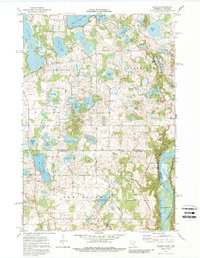
1974 Map of Scandia
USGS Topo · Published 1988About this map
The St Croix River defines the eastern boundary of this mid-1970s survey, marking the state line between Minnesota and Wisconsin. This glacial landscape is saturated with water, featuring a dense network of lakes including Chisago Lake, South Center Lake, and the chain of First, Second, Third, and Fourth lakes. The settlement of Scandia serves as a local anchor, supported by rural landmarks such as Elim Cem and Johnson Memorial Park. To the east, the terrain drops toward the river valley at Cedar Bend, where the Rustream State Wildlife Management Area and McLeods Slough highlight the preserved riparian environment. Cultural sites like St Francis Xavier Ch and the Panola Cem are scattered across the townships of New Scandia and Franconia, documenting the era's established community footprint.
Find a feature on this map
51 named features on this map. Tap any name to fly to it.
Don’t see what you’re looking for? This feature index may not catch every label — zoom into the map to look around manually.
Map Details
Editions of this 1974 Scandia Map
3 editions found
Other maps of this area

1900 · St Croix Dalles
USGS Topo · 1:62,500

1901 · St Croix Dalles
USGS Topo · 1:62,500

1948 · New Richmond
USGS Topo · 1:62,500

1948 · Stillwater
USGS Topo · 1:62,500

1949 · New Richmond
USGS Topo · 1:62,500

1949 · Stillwater
USGS Topo · 1:62,500

1953 · Stillwater
USGS Topo · 1:250,000

1954 · Hugo
USGS Topo · 1:24,000

1955 · St. Croix Dalles
USGS Topo · 1:62,500

1955 · Marine
USGS Topo · 1:24,000