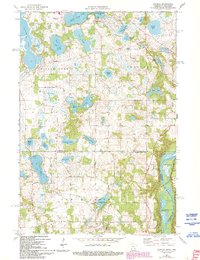
1974 Map of Scandia
USGS Topo · Published 1993About this map
The glacial landscape of the Chisago and Washington County border comes into sharp focus in this late 20th-century survey, defined by a dense concentration of kettle lakes and the meandering St Croix River. The settlement of Scandia serves as a focal point in the southern portion of the map, situated near Johnson Memorial Park and the Elim Cemetery. This area highlights the transition from agricultural and rural residential patterns to managed natural spaces, as seen with the Belstrom State Wildlife Management Area nestled along McLeods Slough.
Find a feature on this map
49 named features on this map. Tap any name to fly to it.
Don’t see what you’re looking for? This feature index may not catch every label — zoom into the map to look around manually.
Map Details
Editions of this 1974 Scandia Map
3 editions found
Other maps of this area

1900 · St Croix Dalles
USGS Topo · 1:62,500

1901 · St Croix Dalles
USGS Topo · 1:62,500

1948 · New Richmond
USGS Topo · 1:62,500

1948 · Stillwater
USGS Topo · 1:62,500

1949 · New Richmond
USGS Topo · 1:62,500

1949 · Stillwater
USGS Topo · 1:62,500

1953 · Stillwater
USGS Topo · 1:250,000

1954 · Hugo
USGS Topo · 1:24,000

1955 · St. Croix Dalles
USGS Topo · 1:62,500

1955 · Marine
USGS Topo · 1:24,000