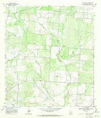
1968 Map of Schattel NW
USGS Topo · Published 1971About this map
West Big Foot Gas Field and the Big Foot Oil Field dominate this 1968 landscape in Frio County, where a network of pipelines and wells defines the local economy. The terrain is deeply incised by a series of south-flowing drainages, including San Miguel Creek, Elm Creek, and Becerra Creek. These watercourses create a distinct pattern of hollows and ridges, such as Mustang Hollow and Sand Hollow, which likely dictated early ranching boundaries and transportation routes.
Find a feature on this map
17 named features on this map. Tap any name to fly to it.
Don’t see what you’re looking for? This feature index may not catch every label — zoom into the map to look around manually.
Map Details
Editions of this 1968 Schattel NW Map
2 editions found
Other maps of this area

1927 · Pearsall
USGS Topo · 1:62,500

1934 · Schattel
USGS Topo · 1:62,500

1942 · Natalia
USGS Topo · 1:62,500

1953 · Crystal City
USGS Topo · 1:250,000

1954 · San Antonio
USGS Topo · 1:250,000

1955 · Crystal City
USGS Topo · 1:250,000

1957 · San Antonio
USGS Topo · 1:250,000

1961 · Crystal City
USGS Topo · 1:250,000

1964 · Pearsall South
USGS Topo · 1:24,000

1964 · Ghost Hill
USGS Topo · 1:24,000