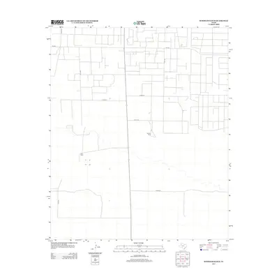
2012 Map of Schooler Ranch
USGS Topo · Published 2012About this map
Schooler Ranch and Close Ranch anchor this West Texas landscape in Cochran County, where large-scale ranching and the grid of rural transportation define the geography. The survey reveals a highly organized network of county and farm-to-market roads, including Fm-1585 and Co Hwy-240, which facilitate the movement of livestock and materials across the arid plains. The linear precision of the road system, with labels like Co Hwy-250 and Co Hwy-260, illustrates the methodical division of land common in the Llano Estacado region. While sparse in dense settlements, the map documents the essential landmarks of Texas ranching history, capturing the infrastructure required to manage vast tracts of land in the early 21st century.
Find a feature on this map
11 named features on this map. Tap any name to fly to it.
Don’t see what you’re looking for? This feature index may not catch every label — zoom into the map to look around manually.
Map Details
Editions of this 2012 Schooler Ranch Map
This is the sole edition of this map. No revisions or reprints were ever made.
Other maps of this area

1954 · Brownfield
USGS Topo · 1:250,000

1958 · Brownfield
USGS Topo · 1:250,000

1962 · Brownfield
USGS Topo · 1:250,000

1969 · Lehman
USGS Topo · 1:24,000

1970 · Plains 1 SW
USGS Topo · 1:24,000

1970 · Morton SW
USGS Topo · 1:24,000

1970 · Whiteface SW
USGS Topo · 1:24,000

1970 · Plains 1 NW
USGS Topo · 1:24,000

1971 · Schooler Ranch
USGS Topo · 1:24,000
1971 · Two B Ranch
USGS Topo · 1:24,000