1971 Map of Scipio
USGS Topo · Published 1973About this map
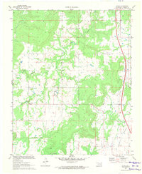
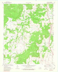
Scipio and Ulan sit at the center of this rural Oklahoma landscape as it appeared in the early 1970s. The topography is defined by the winding course of Scipio Creek and the open expanse of Tannehill Prairie to the southeast. This survey, conducted in cooperation with the Oklahoma Water Resources Board, provides a clear view of the area's social infrastructure through several community hubs. Local history and genealogy researchers will find multiple burial sites, including Ulan Cem, Hughlow Cem, and Lone Grove Cem, often situated near rural centers like Lone Grove Ch. The presence of a Gas Well and Drill Hole reflects the underlying energy activity of the region, while the Indian Nation Turnpike cuts a modern path through the eastern portion of the quadrangle, signaling the era's evolving transportation network.
Find a feature on this map
11 named features on this map. Tap any name to fly to it.
Don’t see what you’re looking for? This feature index may not catch every label — zoom into the map to look around manually.
Map Details
Editions of this 1971 Scipio Map
2 editions found
Other maps of this area

1896 · Coalgate
USGS Topo · 1:125,000

1898 · McAlester
USGS Topo · 1:125,000

1899 · Coalgate
USGS Topo · 1:125,000

1900 · Canadian
USGS Topo · 1:125,000

1900 · Wewoka
USGS Topo · 1:125,000

1900 · Coalgate
USGS Topo · 1:125,000

1909 · Mc Alester
USGS Topo · 1:125,000

1946 · Fort Smith
USGS Topo · 1:250,000

1950 · Mcalester
USGS Topo · 1:250,000

1954 · Oklahoma City
USGS Topo · 1:250,000