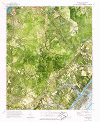
1970 Map of Scotts Hill
USGS Topo · Published 1987About this map
Scotts Hill and the surrounding coastal landscape of New Hanover County are depicted here during a period of transition in the late 1960s. The orthophotomap format combines traditional topographic contours with aerial imagery, revealing the dense vegetation and drainage patterns of the Atlantic coastal plain. A series of tidal creeks, including Pages Creek, Futch Creek, and Howe Creek, snake through the lowlands toward the Intracoastal Waterway and Middle Sound. The map captures the infrastructure of the era, from the Seaboard Coast Line railroad to local landmarks like Oak Grove Ch and Prospect Cem. The terrain ranges from the interior quarries near the NE Cape Fear R to the developing sands of Figure Eight Island, providing a detailed look at the interface between inland agriculture and the burgeoning coastal community.
Find a feature on this map
33 named features on this map. Tap any name to fly to it.
Don’t see what you’re looking for? This feature index may not catch every label — zoom into the map to look around manually.
Map Details
Editions of this 1970 Scotts Hill Map
3 editions found

Other maps of this area

1942 · Topsail
USGS Topo · 1:62,500

1942 · Wilmington
USGS Topo · 1:62,500

1947 · Rocky Point
USGS Topo · 1:62,500

1948 · Topsail
USGS Topo · 1:62,500

1948 · Wilmington
USGS Topo · 1:62,500

1953 · Beaufort
USGS Topo · 1:250,000

1954 · Beaufort
USGS Topo · 1:250,000

1970 · Hampstead
USGS Topo · 1:24,000
1970 · Wrightsville Beach
USGS Topo · 1:24,000

1970 · Topsail
USGS Topo · 1:24,000