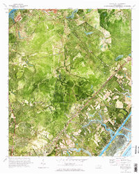
1970 Map of Scotts Hill
USGS Topo · Published 1987About this map
The boundary between Pender Co New Hanover Co cuts through a landscape defined by the transition from upland woods to the tidal marshes of the Atlantic coast. This orthophotomap, based on 1969 aerial photography, reveals the established footprints of Scotts Hill and Murraysville as they appeared before modern coastal development intensified. The Seaboard Coast Line RR provides a clear industrial corridor through the inland sections, passing near the growing clusters at Ogden and Midway.
Find a feature on this map
33 named features on this map. Tap any name to fly to it.
Don’t see what you’re looking for? This feature index may not catch every label — zoom into the map to look around manually.
Map Details
Editions of this 1970 Scotts Hill Map
3 editions found

Other maps of this area

1942 · Topsail
USGS Topo · 1:62,500

1942 · Wilmington
USGS Topo · 1:62,500

1947 · Rocky Point
USGS Topo · 1:62,500

1948 · Topsail
USGS Topo · 1:62,500

1948 · Wilmington
USGS Topo · 1:62,500

1953 · Beaufort
USGS Topo · 1:250,000

1954 · Beaufort
USGS Topo · 1:250,000

1970 · Hampstead
USGS Topo · 1:24,000
1970 · Wrightsville Beach
USGS Topo · 1:24,000

1970 · Topsail
USGS Topo · 1:24,000