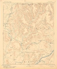
1892 Map of Scottsboro
USGS Topo · Published 1909About this map
The Tennessee River snakes through the southeastern corner of this North Alabama landscape, serving as a vital artery for river travel and trade long before modern bridges dominated the region. Active river crossings like Section Ferry and Caldwell's Ferry provide the primary links between the Cumberland Plateau and the river valley. The map documents the late nineteenth-century industrial and agricultural footprint, from the Bell Factory along the Flint River to the rail hubs of Scottsboro and Larkinsville. Dramatic topographical variations are evident as the Paint Rock River carves through deep valleys like Kennamer Cove and Williams Cove. Transportation is defined by the corridors of the Memphis and Charleston Railroad and the Nashville Chattanooga and St Louis Railroad, which connected these rural Jackson County settlements to the broader Southern market.
Find a feature on this map
88 named features on this map. Tap any name to fly to it.
Don’t see what you’re looking for? This feature index may not catch every label — zoom into the map to look around manually.
Map Details
Editions of this 1892 Scottsboro Map
5 editions found
Other maps of this area

1885 · Gadsden
USGS Topo · 1:125,000

1886 · Stevenson
USGS Topo · 1:125,000

1888 · Cullman
USGS Topo · 1:125,000

1888 · Gadsden
USGS Topo · 1:125,000

1888 · Scottsboro
USGS Topo · 1:125,000

1888 · Huntsville
USGS Topo · 1:125,000

1892 · Cullman
USGS Topo · 1:125,000

1892 · Huntsville
USGS Topo · 1:125,000

1892 · Scottsboro
USGS Topo · 1:125,000

1892 · Stevenson
USGS Topo · 1:125,000