
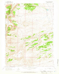
2012 Map of Scrivner Butte
USGS Topo · Published 2012About this map
Scrivner Butte and the surrounding high desert of Sweetwater County define this landscape along the Wyoming-Colorado border. The map highlights a scattered ranching economy, where family-named sites like Rife Ranch, Graham Ranch, and Scofield Ranch occupy a terrain carved by deep drainages such as Scrivner Canyon and Owl Canyon. This 2012 survey illustrates the coexistence of traditional livestock operations with modern energy extraction, notably at the Canyon Creek Gas Field and Diamond Field. Water is a critical focus in this arid environment, with vital sources documented at McKnight Spring and Two Bar Spring. The regional road network, including the Bitter Creek Rd and Hiawatha Rd, connects these isolated homesteads and industrial sites through the vastness of Horseshoe Basin.
Find a feature on this map
28 named features on this map. Tap any name to fly to it.
Don’t see what you’re looking for? This feature index may not catch every label — zoom into the map to look around manually.
Map Details
Editions of this 2012 Scrivner Butte Map
This is the sole edition of this map. No revisions or reprints were ever made.
Other maps of this area

1954 · Vernal
USGS Topo · 1:250,000

1954 · Rock Springs
USGS Topo · 1:250,000

1958 · Vernal
USGS Topo · 1:250,000

1958 · Rock Springs
USGS Topo · 1:250,000

1960 · Vernal
USGS Topo · 1:250,000

1962 · Rock Springs
USGS Topo · 1:250,000

1963 · Four J Rim
USGS Topo · 1:24,000
1963 · Potter Mountain
USGS Topo · 1:24,000

1963 · Erickson-Kent Ranch
USGS Topo · 1:24,000

1963 · Scrivner Butte
USGS Topo · 1:24,000