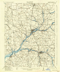
1915 Map of Seaford
USGS Topo · Published 1936About this map
Seaford and its neighboring towns on the Delmarva Peninsula are defined by the winding course of the Nanticoke River and its major tributary, Broad Creek. At this time, the river served as a vital commercial artery, with numerous landings and wharves such as Ellis Wharf and Hurts Wharf facilitating trade alongside the Steamboat Route. The map illustrates a landscape of established mill seats like Butler Mill and Craigs Mill, alongside numerous ponds including Williams Pond and Records Pond that powered local industry.
Find a feature on this map
101 named features on this map. Tap any name to fly to it.
Don’t see what you’re looking for? This feature index may not catch every label — zoom into the map to look around manually.
Map Details
Editions of this 1915 Seaford Map
4 editions found
Other maps of this area

1901 · Salisbury
USGS Topo · 1:62,500

1902 · Pittsville
USGS Topo · 1:62,500

1903 · Nanticoke
USGS Topo · 1:62,500

1905 · Denton
USGS Topo · 1:62,500

1905 · Hurlock
USGS Topo · 1:62,500

1915 · Seaford
USGS Topo · 1:62,500

1917 · Millsboro
USGS Topo · 1:62,500

1918 · Cedar Creek
USGS Topo · 1:62,500

1918 · Harrington
USGS Topo · 1:62,500

1919 · Cedar Creek
USGS Topo · 1:62,500