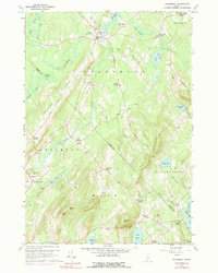
1960 Map of Searsmont
USGS Topo · Published 1991About this map
The St George River flows through the heart of this mid-coast Maine landscape, anchoring the village of Searsmont and providing the power for local industry like Shermans Mill. Small hamlets and family-named intersections such as Gushees Corner, Bickfords Corner, and Knights Corner define the settlement pattern, which is heavily influenced by the prominent north-south orientation of Appleton Ridge and Muzzy Ridge. Genealogists will find a dense concentration of burial sites, including the Oak Grove Cem and East Searsmont Cem, reflecting the early farming families of Belmont and Appleton. The map also captures the transition from agriculture to natural recovery, with landmarks like Whitney Bog and Quantabacook Lake interspersed among old gravel pits and woodlots that characterize the rural Waldo and Knox County borderlands during the mid-twentieth century.
Find a feature on this map
68 named features on this map. Tap any name to fly to it.
Don’t see what you’re looking for? This feature index may not catch every label — zoom into the map to look around manually.
Map Details
Editions of this 1960 Searsmont Map
4 editions found
Other maps of this area

1904 · Rockland
USGS Topo · 1:62,500

1906 · Rockland
USGS Topo · 1:62,500

1913 · Waldoboro
USGS Topo · 1:48,000

1915 · Waldoboro
USGS Topo · 1:62,500

1915 · Belfast
USGS Topo · 1:62,500

1916 · Liberty
USGS Topo · 1:62,500

1917 · Belfast
USGS Topo · 1:62,500

1941 · Belfast
USGS Topo · 1:62,500

1941 · Rockland
USGS Topo · 1:62,500

1941 · Waldoboro
USGS Topo · 1:62,500