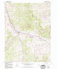
1965 Map of Sedalia
USGS Topo · Published 1994About this map
Sedalia serves as the focal point of this mid-1960s landscape, situated at the confluence where West Plum Creek and Jarre Creek join East Plum Creek to form Plum Creek. The era's transportation network is defined by the parallel tracks of the At&Sf Rr and D&Rgw Rr, which cut through the valley alongside the early residential developments of Kellytown and Beverly Hills. To the north, Daniels Park and the Wildcat Point Historical Monument overlook the terrain from Wildcat Point, while the presence of the Ute Mine and a Quarry near the Castle Rock Corporate Boundary reflect the local extractive economy.
Find a feature on this map
47 named features on this map. Tap any name to fly to it.
Don’t see what you’re looking for? This feature index may not catch every label — zoom into the map to look around manually.
Map Details
Editions of this 1965 Sedalia Map
4 editions found
Other maps of this area

1890 · East Denver
USGS Topo · 1:125,000

1893 · Platte Canyon
USGS Topo · 1:125,000

1894 · Castle Rock
USGS Topo · 1:125,000

1899 · West Denver
USGS Topo · 1:125,000

1913 · Castle Rock
USGS Topo · 1:125,000

1935 · East Denver Nos. 3 and 4
USGS Topo · 1:48,000

1940 · Castle Rock
USGS Topo · 1:62,500

1942 · Highland Ranch
USGS Topo · 1:31,680

1942 · Parker
USGS Topo · 1:31,680

1942 · Littleton
USGS Topo · 1:31,680