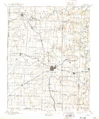
1894 Map of Sedalia
USGS Topo · Published 1939About this map
Sedalia serves as a central hub of nineteenth-century transportation in this central Missouri landscape, where multiple branches of the Missouri Pacific Railroad and the Missouri Kansas and Texas Railroad converge. The survey reveals a sophisticated network of small farming communities and specialized settlements, from the mineral water resort of Mc Allister Springs and Sweet Springs in the northwest to the agricultural trade centers of Smithton and Lamonte.
Find a feature on this map
82 named features on this map. Tap any name to fly to it.
Don’t see what you’re looking for? This feature index may not catch every label — zoom into the map to look around manually.
Map Details
Editions of this 1894 Sedalia Map
5 editions found

Other maps of this area

1885 · Warrensburg
USGS Topo · 1:125,000

1887 · Clinton
USGS Topo · 1:125,000

1887 · Sedalia
USGS Topo · 1:125,000

1887 · Warsaw
USGS Topo · 1:125,000

1887 · Warrensburg
USGS Topo · 1:125,000

1888 · Versailles
USGS Topo · 1:125,000

1888 · Boonville
USGS Topo · 1:125,000

1889 · Lexington
USGS Topo · 1:125,000

1890 · Glasgow
USGS Topo · 1:125,000

1890 · Marshall
USGS Topo · 1:125,000