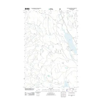
2011 Map of Seeley Lake West
USGS Topo · Published 2011About this map
Seeley Lake and Placid Lake dominate this high-country landscape in Missoula County, where the Clearwater River connects a network of glacial lakes and mountain streams. By the early 21st century, the area had become a well-established recreational hub, evidenced by the presence of Tamaracks Resort, Camp Paxson, and several organized sites like River Point Campground and Seeley Lake Campground. A complex network of forest access roads, including W Side Bypass Rd and Jocko Rd, winds through the timbered terrain toward the Double Arrow Lookout. Beyond the main lakes, smaller water bodies like Hidden Lake and Tuppers Lake are tucked into the drainages of Archibald Creek and Placid Creek. The map provides a detailed view of the shorelines and topography before significant modern development, showing the proximity of the Jocko Park boundary to the western lake basins.
Find a feature on this map
38 named features on this map. Tap any name to fly to it.
Don’t see what you’re looking for? This feature index may not catch every label — zoom into the map to look around manually.
Map Details
Editions of this 2011 Seeley Lake West Map
This is the sole edition of this map. No revisions or reprints were ever made.
Other maps of this area

1902 · Ovando
USGS Topo · 1:125,000

1905 · Ovando
USGS Topo · 1:125,000

1921 · Elbow Lake
USGS Topo · 1:125,000

1955 · Choteau
USGS Topo · 1:250,000

1957 · Choteau
USGS Topo · 1:250,000

1958 · Choteau
USGS Topo · 1:250,000

1962 · Choteau
USGS Topo · 1:250,000

1965 · Upper Jocko Lake
USGS Topo · 1:24,000
1965 · Gold Creek Peak
USGS Topo · 1:24,000

1965 · Seeley Lake West
USGS Topo · 1:24,000